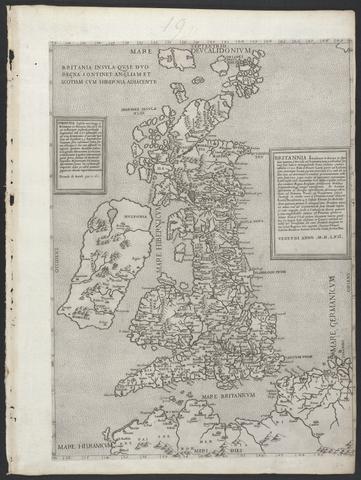
Britannia insula quae duo regna continet Angliam et Scotiam cum Hibernia adiacente
MDLVI [1556]
2
Boazio, Baptista
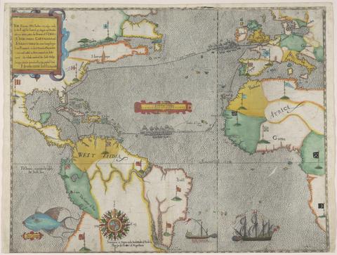
The famouse West Indian voyadge made by the Englishe fleete of 23 shippes and barkes
[1589?]
3
Hollar, Wenceslaus, 1607–1677
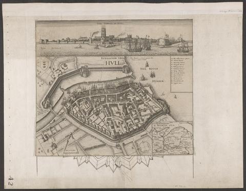
Kyngeston vpon Hvll
circa 1642
4
Great Britain. Ordnance Survey
[Old series Ordnance Survey maps of England and Wales]
1805-1834 [i.e. 1834-1835?]
5
Speed, John, 1552?-1629
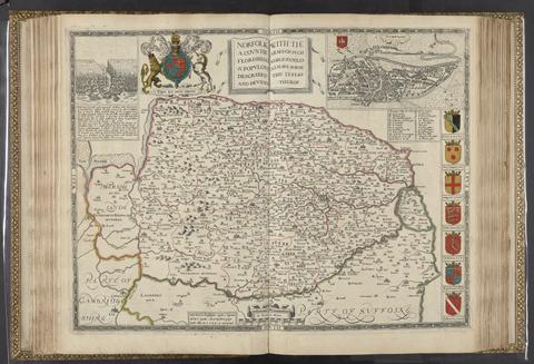
The theatre of the empire of Great Britaine
[1612]
6
Ogilby, John, 1600–1676
Britannia, volume the first, or, An illustration of the kingdom of England and dominion of Wales
MDCLXXV [1675]
7
Lily, George, active 1528–1559
Britania insula quae duo regna continet Angliam et Scotiam cum Hibernia adiacente
anno MDLXII [1562]
8
A plan of the harbour and town of Toulon, and places adjacent
1756
9
Speed, John, 1552?-1629
The theatre of the empire of Great Britaine
1627
10
Faden, William, 1749–1836
The roads of Great Britain
1800
11
Speed, John, 1552?-1629
[The theatre of the empire of Great Britaine]
[1646?]
12
Great Britain. Ordnance Survey
[Old series Ordnance Survey maps of England and Wales]
[1839-1874?]
13
Gardner, W. R.
New and Improved map of England and Wales, including the principal part of Scotland
16th. April 1823
14
Valck, G. (Gerard), 1651–1726
Magna Britannia, aut Anglia, Scotia et Hibernia, quarum prior divisa in septem Regna, sive Provincias, dictas Northumbriam, Merciam, Angliam Orient. Essexiam, Cantium, Sussexiam, Westsexiam, et Princi. Walliae. posterior in Septent. et Austr. Scotiam. postrema in quatuor Provincias Ultoniam, Lageniam, Momoniam, et Conagtiam
[approximately 1705]
15
Peacock, W. (William), -1910
Peacock's Superior dissected maps
[between 1875 and 1909]
16
Froggett, John, active 1808–1821
Froggett's survey of the country thirty miles round London, 1836
[1836]
17
Froggett, John, active 1808–1821
Froggett's Survey of the country thirty miles round London
1839
18
Morden, Robert, approximately 1650–1703
A new mapp of England Scotland and Ireland
[1678]
19
Valck, G. (Gerard), 1651–1726
Les isles Britanniques, qui contiennent les Royaumes d'Angleterre, Escosse, et Irlande
[approximately 1695]
20
Boazio, Baptista
S. Augustini pars est terrae Florida
[1588?]
21
Smith, Charles, map publisher
A new plan of the road from London to Dover and from Calais to Paris
1801
22
The railways in Great Britain
[between 1840 and 1862]
23
Ordnance Survey (Ireland)
Ordnance Survey of Ireland
[1858-1862]
24
Peacock, W. (William), -1910
Peacock's improved double dissection
[between 1875 and 1909]
25
Speed, John, 1552?-1629
Theatrum Imperij Magnae Britanniae
anno cum privilegio 1616
26
Hobson, William Colling
Hobson's fox-hunting atlas
[1850?]
27
Jansson, Jan, 1588–1664
Illustriorum principumque urbium septentrionalium Europae tabulae
[1657]
28
Ogilby, John, 1600–1676
Britannia depicta, or, Ogilby improv'd
1749
29
Great Britain. Ordnance Survey
[Old series Ordnance Survey maps of England and Wales]
Novr. 9th, 1843 [i.e. ca. 1853-1874?]
30
Collins, Greenvile, active 1669–1698
Great Britain's coasting-pilot ...
1693
31
Speed, John, 1552?-1629
The theatre of the empire of Great-Britain
MDCLXXVI [1676]
32
Keere, Pieter van den, 1571–approximately 1646
[Atlas of the British Isles]
[Amsterdam?] :
33
Greenough, George Bellas, 1778–1855
A geological map of England & Wales
November 1st, 1819 [that is, 1820]
34
Speed, John, 1552?-1629
The theatre of the empire of Great Britaine
[1650]
35
Boazio, Baptista
The famouse West Indian voyadge made by the Englishe fleete of 23 shippes and barkes
[1589?]
36
Dawson, Robert Kearsley, 1798–1861
Plans of the cities and boroughs of England and Wales
1832
37
Ogilby, John, 1600–1676
Britannia, volume the first, or, An illustration of the kingdom of England and dominion of Wales
MDCLXXV [1675]
38
Britannia prout divisa fuit temporibus Anglo-Saxonum praesertim durante illorum heptarchia
[1645]
39
Greenough, George Bellas, 1778–1855
A geological map of England & Wales
November 1st, 1819 [that is, 1820]
40
Munns, John
A map of the roads of England & Wales
[18--?]
41
Speed, John, 1552?-1629
[Proof engravings for The theatre of the empire of Great Britaine]
[circa 1610?]
42
Bradshaw's railway map of Great Britain and Ireland
1873
43
Hobson, William Colling
Hobson's fox-hunting atlas
[1848]
44
Peacock, W. (William), -1910
Peacock's improved double dissection
[between 1875 and 1909]
45
Dawson, Robert Kearsley, 1798–1861
[Plans of borough towns included in List no. VIII on Parliamentary representation, 1832]
[1832]
46
Lily, George, active 1528–1559
Britanniae insulae quae nunc Angliae et Scotiae regna continet cum Hibernia adiacente
MDLVIII [1558]
47
Lily, George, active 1528–1559
Britanniae insulae quae nunc Angliae et Scotiae regna continet cum Hibernia adjacente nova descriptio
MDXLVI [1546]
48
Rapkin, J.
The illustrated atlas and modern history of the world
[1851?]
49
Mogg, Edward
Mogg's New map of England and Wales, with part of Scotland
[183-?]
50
Cheffins, Charles F
Cheffins's map of the English & Scotch railways
[1843]
51
Collins, Greenvile, active 1669–1698
Great Britain's coasting-pilot
MDCCLXXVI [1776]
52
John Bartholomew and Son
Royal map
[1977?]
53
Gardens explorer map, Hampton Court Palace
[2018?]
54
John Bartholomew and Son
Bartholomew's revised half-inch map
1964-1968
55
Dorling, Daniel
People and places
2016
56
Blaeu, Willem Janszoon, 1571–1638
Blaeu's Atlas of England, Scotland, Wales and Ireland