Rare Books and ManuscriptsFolio C 2010 6eYale Center for British Art, Paul Mellon Collection
Copyright Status:
Public Domain
Related Content:
View catalog record for a series of plans for the fortifications at Hull, by Martin Beckman
http://hdl.handle.net/10079/bibid/13070241
Classification:
Maps & Atlas (printed)
Notes:
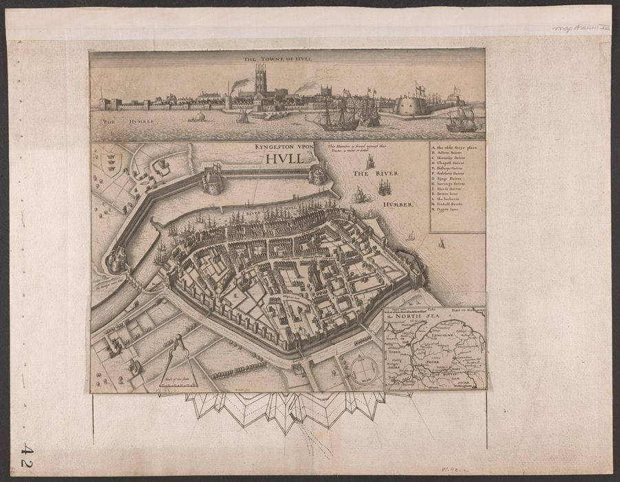
The seaport of Hull was an important 17th century English bulwark against naval attack or incursions of Scottish armies. After Hull turned against Charles I in 1640, the King twice (without success) besieged the town in 1642, the likely year of issue of the present print. Cf. Parry.The strategic importance of the port of Hull led to the planning and construction of extensive fortifications under Charles II and James II. The engineer in charge of the works at Hull was Sir Martin Beckman (d. 1702), "second engineer" of Great Britain under Sir Bernard de Gomme. For more on the activity of Bernard de Gomme and Martin Beckman at Hull, see: Saunders, A. Fortress builder, pages 229-231.Pennington, R. Descriptive catalogue of the etched work of Wenceslaus Hollar, 1607-1677, 984Parry, G. Hollar's England, 10Skelton, R. "The Royal map collections of England." In Imago mundi, vol. 13 (1956), p. 181-183Wallis, H. "The Royal map collections of England." In Revista da Universidade de Coimbra, vol. XXVIII (1980), p. 466-467Provenance: From the collection of George Legge, first Baron Dartmouth, 1648-1691 (see Sotheby's sale, March 8-10, 1948). Baron Dartmouth was Master-General of the Ordnance to Charles II and James II. His collection of maps was partly abstracted from Royal map collections, an arrangement described by Pepys in Bodleian Library MS Rawl. A. 171, 17r-20v. See also Skelton and Wallis. The map is numbered "42" in ink and "vi.42.a" in graphite.Selected exhibitions: "The Mapmaker's art: 300 years of British cartography" (Yale Center for British Art, January 17-March 12, 1989).Engraved aerial view of the city of Hull (circa 1642), with additions in pen and black ink. The engraved portion includes a bird's-eye view of the city, together with a view of the city as seen from the Humber estuary (across the top of the print), and a small inset map of the region surrounding Hull, including parts of Lincolnshire, Yorkshire, and Nottinghamshire. Both views of Hull offer detailed depictions of city buildings, along with the two forts guarding the harbor and a number of ships on the Humber.The manuscript additions are made in pen and ink, probably by Sir Martin Beckman, the engineer in charge of the improvements at Hull, 1681-1682. They depict a ring of fortifications on the west side of the city, along Beverley Gate. The fortifications are similar to those depicted in a series of drawings by Beckman (with his signature), ca. 1681-1682. The related drawings -- Dartmouth nos. 34-37 -- are cataloged separately (see link herewith).The manuscript additions are drawn directly on the sheet of paper to which the engraving is mounted; the lower portion of the engraving (not mounted) may be lifted up to reveal the proposed fortification changes underneath.
Exhibition History:
The Mapmaker's Art: 300 Years of British Cartography (Yale Center for British Art, January 17, 1989-March 12, 1989)
Subject Terms:
Fortification -- Great Britain. | Great Britain -- History, Military -- 1603–1714. | Great Britain -- Defenses. | Hull (England) -- Aerial views -- Early works to 1800. | Hull (England) -- Maps. | Hull (England) -- Buildings, structures, etc.
Form/Genre:
Maps -- England -- Hull. | Ink drawings.
Contributors:
Beckman, Martin, -1702. | Dartmouth, George Legge, Baron, 1648–1691, former owner.