Historical descriptions of new and elegant picturesque views of the antiquities of England and Wales : being a grand copper-plate repository of elegance, taste, and entertainment : containing a new and complete collection of superb views of all the most remarkable ruins and antient buildings, such as abbeys, castles, monasteries, priories ... : accompanied by elegant letter-press descriptions ... a complete set of county-maps ... together with an authentic account of Doomsday-Book ... / published under the inspection of Henry Boswell ... assisted by Robert Hamilton ... and other ingenious gentlemen ...
Published / Created:
London : Printed for Alex. Hogg, at the King's-Arms, No. 16, Paternoster-Row, and sold by all booksellers, printsellers, and news-carriers, in town and country, [1786]
Physical Description:
1 v. (various pagings) : ill. ; 40 cm.
Holdings:
Rare Books and Manuscripts DA620 .H57 1786+ Oversize Yale Center for British Art, Paul Mellon Collection
Rare Books and Manuscripts Folio A 2021 2 Yale Center for British Art, Gift of Elizabeth Langhorne
Copyright Status:
Public Domain
Related Content:
View a selection of digital images in the Yale Center for British Art's online catalogue
https://collections.britishart.yale.edu/catalog/orbis:3672792
Classification:
Books
Notes:
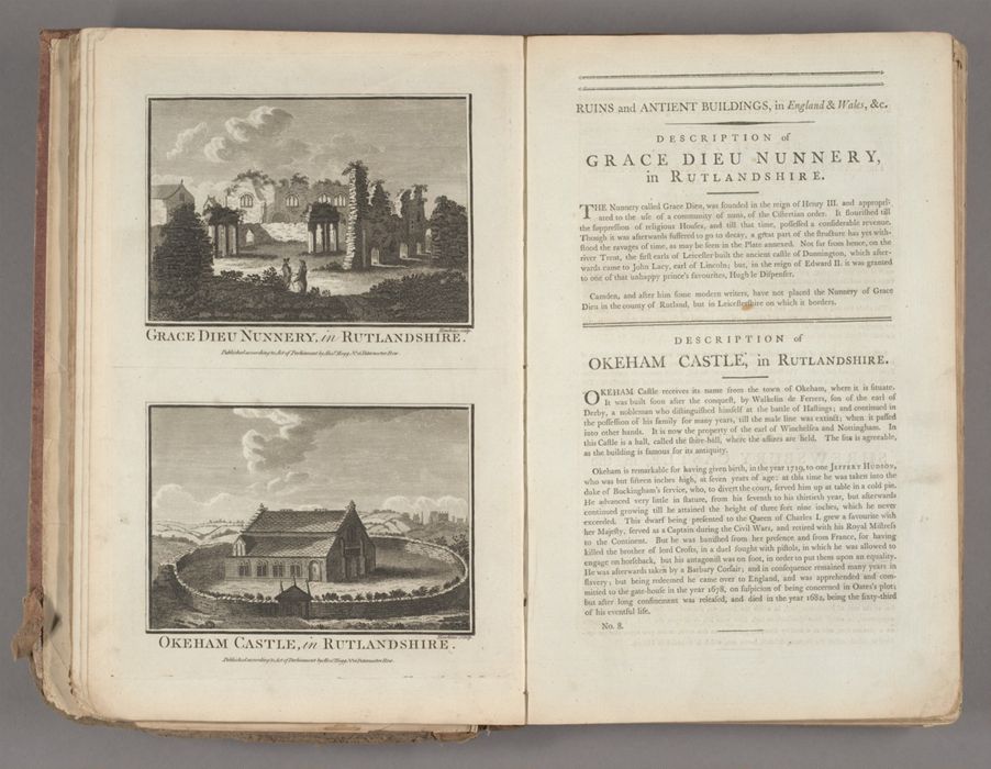
Henry Boswell is probably a pseudonym. Cf. ESTC.Engravings by (W.P.?) Carey, M. Coote, J. Dadley, John Eastgate, Hawkins, J. Hogg, John Lodge, (Strickland?) Lowry, Neigel, Noble, Page, John Peltro, Robert Pollard, John Record, George Richardson, Henry Roberts, J. Simpson, Samuel Sparrow, C. Taylor, Thomas Thornton, John Walker, William Walker, Warren, and J.G. Wooding; after T.F. Burney, John Hamilton, and Samuel Wale.Maps engraved by Thomas Conder; some drawn by Thomas Kitchen.Published in 100 parts, unpaginated, and 11 additional parts, numbered 16-25 and 27, signed A-L and paginated 1-42, entitled 'A general history of antient castles, forts, &c.', together with a preface, list of subscribers, and a list of plates.Frontispiece dated 1786.Contains 50 maps. Those of the counties of England, except Yorkshire, are by Thomas Kitchin and originally appeared in the London Magazine from 1747-1760. They are without imprints and all evidence of their connection with the magazine has been removed. Cf. Chubb.Includes list of the plates, Directions to the binder, and List of subscribers at end.Many of the engraved illustrations are printed two to a page.English short title catalogue, T122443 British Architectural Library. Early printed books, 1478-1840, 1508 Chubb T. Printed maps in the atlases of Great Britain and Ireland, CCLVIILowndes, W.T. Bibliographer's manual of English literature (1871 edition), v. 1, 228 BAC: British Art Center DA620 .H57 1786+ copy is incomplete: lacks 20 of the 50 maps cited in Chubb. Lacks the index of plates, directions to the binder and list of subscribers. The plates are bound in at the end. Armorial bookplates: George H. Lynch; Mexborough. Bound in later three quarter brown morocco.BAC: British Art Center Folio A 2021 2 copy is incomplete: lacks maps, index of plates, directions to the binder, and list of subscribers. Bound in contemporary red cloth.
Subject Terms:
Historic buildings -- Great Britain -- Early works to 1800. | Historic buildings -- Great Britain -- Pictorial works -- Early works to 1800. | Great Britain -- Antiquities -- Early works to 1800. | Great Britain -- Antiquities -- Pictorial works -- Early works to 1800. | Great Britain -- Maps -- Early works to 1800. | Coins, English -- Early works to 1800. | Seals (Numismatics) -- Early works to 1800. | England -- Antiquities -- Early works to 1800. | Wales -- Antiquities -- Early works to 1800. | Hogg, Alex. -- Publisher. | Lynch, George H. -- Bookplate. | Mexborough -- Bookplate.