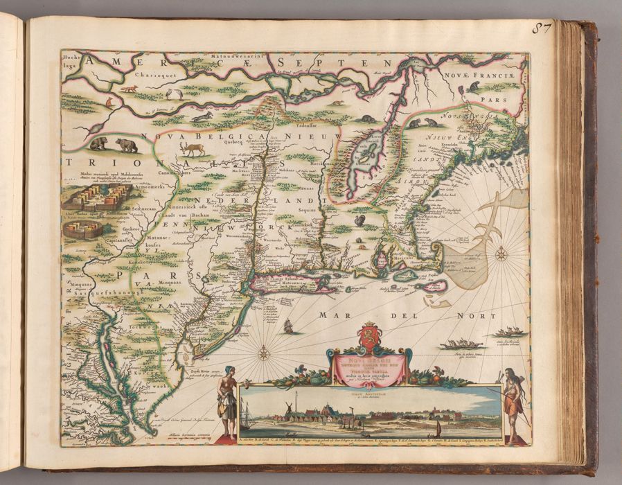
Novi Belgii Novaeque, Angliae nec non partis Virginiae tabula : multis in locis emendata / per Nicolaum Visscher.
Published / Created:
[Amsterdam?] : [Nicolaes Visscher], [ca. 1684]
Physical Description:
1 map ; 46.1 x 55.9 cm, on sheet 52.4 x 62.9 cm
Holdings:
Rare Books and Manuscripts Folio C 2015 1Yale Center for British Art, Paul Mellon Collection
Copyright Status:
Public Domain
Related Content:
View a selection of digital images in the Yale Center for British Art's online catalogue
https://collections.britishart.yale.edu/catalog/orbis:14625092
Classification:
Maps & Atlas (printed)
Scale:
Scale [ca. 1:2,200,000] -- (W 78.00°--W 66.50°/N 47.00°--N 37.00°).
Notes:
Covers New England and Middle Atlantic region southward to Hampton Roads.Derived from the map Belgii Novi, by Joannes Janssonius, first published in 1651.Campbell's 3rd state (Burden's 4th) of the "Jansson-Visscher series," showing Philadelphia, and with "cum Privil." statement to the left of the view. See: Campbell and Burden.Shows names of colonies, colonial towns, and lands inhabited by Indigenous people.Relief shown pictorially.Meridians numbered 297 to 312 from west to east.Date of publication from Burden.Appears in Atlas minor sive geographia compendiosa, published by Nicolaes Visscher (1649-1702) and his widow in various editions from ca. 1683 to ca. 1716.Campbell, T. New light on the Jansson-Visscher maps of New England (Map Collectors' Circle, no. 24), No. 6, Plate 5Burden, P.D. Mapping of North America, no. 315, pages 406-407BAC: British Art Center copy is bound en plano (unfolded) as map 87 in part 2 of a composite atlas issued by Nicolaes Visscher with title: Atlas minor, sive, Geographia compendiosa, ca. 1716 (Folio C 2015 1) (the numbering written in black ink at top right). Hand-colored, with use of gold in the neat line and to mark select borders.
Subject Terms:
New England -- Maps -- Early works to 1800. | Middle Atlantic States -- Maps -- Early works to 1800. | New York (N.Y.) -- Aerial views -- Early works to 1800. | Indians of North America -- New England -- Maps -- Early works to 1800. | Indians of North America -- Middle Atlantic States -- Maps -- Early works to 1800.