Skip to splash images
Yale Center for British Art Home Page
<< YCBA Home
Yale Center for British Art
<< YCBA Home
Welcome to YCBA Collections Online
The museum is reopening to the public in March 2025.
    Search Options:
Search in
Simple Search
All Fields
Title
Creator
Subject Terms
Call Number
Search Provenance
Fielded
search for
Search
YCBA Collections Search
Toggle facets
Refine your search
Collection
Prints and Drawings
2
Creator
Dawson, Robert Kearsley, 1798–1861
2
Date
1813
2
On-site Access
Accessible by appointment in the Study Room
2
Image Use
Free to Use
2
Image Available
Available
[remove]
2
Classification
Prints
2
Creator Gender
male
2
Period
19th century
2
Materials & Techniques
etching (printing process)
2
hand coloring
2
wove paper
2
Height [cm]
Height [cm] range begin
–
Height [cm] range end
Current results range from
27
to
35
Width [cm]
Width [cm] range begin
–
Width [cm] range end
Current results range from
18
to
32
Work Type
intaglio print
2
Genre
architectural subject
2
still life
[remove]
2
Subject Terms
architectural subject
2
boundaries
2
cartographic material
2
cartography
2
key (text)
2
map
[remove]
2
scale (rule)
2
still life
2
cities
1
divisions
1
islands
1
river
1
streets
1
town
1
towns
1
Associated Places
England
2
United Kingdom
2
Bewdley
1
Europe
1
Hereford and Worcester
1
Severn
1
Worcestershire
1
Credit Line
Yale Center for British Art, Paul Mellon Collection
2
Search Constraints
Start Over
You searched for:
Genre
still life
Remove constraint Genre: still life
Image Available
Available
Remove constraint Image Available: Available
Subject Terms
map
Remove constraint Subject Terms: map
1
-
2
of
2
Sort by collection
collection
relevance
artist (A-Z)
date
title (A-Z)
Number of results to display per page
100 per page
100
per page
50
per page
15
per page
View results as:
List
Masonry
Search Results
1
Print made by Robert Kearsley Dawson, 1798–1861
Map of Worcestershire Showing Western and Eastern Divisions
undated
2
Print made by Robert Kearsley Dawson, 1798–1861
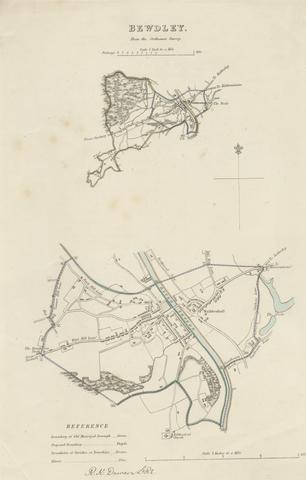
Map of Bewdley from the Ordnance Survey
undated